Buffering Tools in ArcMap
To create buffers, GIS software tools like ArcMap or QGIS can be employed. These tools help visualize and analyze specific areas around geographic features.
Introduction
In the world of Geographic Information Systems (GIS), one common spatial analysis technique is buffering. Buffers find their application in diverse fields like urban planning, environmental management, transportation, and public health. This article will help you understand what buffers are in GIS, their uses, different types, and how to determine the size of a buffer.
What is a Buffer in GIS?
A buffer in GIS is like a protective zone created around a geographic feature, such as a point, line, or polygon, based on a specific distance. Imagine it as a bubble that surrounds a feature, measured in units like feet, meters, or kilometers. For instance, a 10-meter buffer around a river results in a corridor 20 meters wide, covering both sides of the river.
Purpose of Buffers
Buffers are crafted to identify and analyze spatial relationships between features within a set distance. They help answer questions like, “What features are within a certain distance from a given point?” or “How many road segments intersect a specific buffer zone?”
Uses of Buffers
Buffers are commonly used in GIS analysis. Cities often create buffers around sensitive areas, like schools, to restrict certain businesses, such as selling alcohol within a specified distance. Additionally, businesses use buffers to analyze demographics by considering the distance of customers from their store.
Buffers and GIS Data Types
Buffering involves measuring outward distances from an object and can be applied to point, line, and area data. The result is a polygon file, helping visualize the buffered area.
Uniform and Variable Buffers
Uniform buffers have a consistent distance, like creating a 50-foot buffer around rivers. On the other hand, variable buffers change based on factors like noise levels around a street network, using larger distances for busy roads and shorter distances for quieter ones.

Elevation-Based Variable Buffers
Cities with different elevations can have buffers of varying sizes. For example, a city with higher elevation may have a larger buffer area, as illustrated in the map of Oklahoma cities.

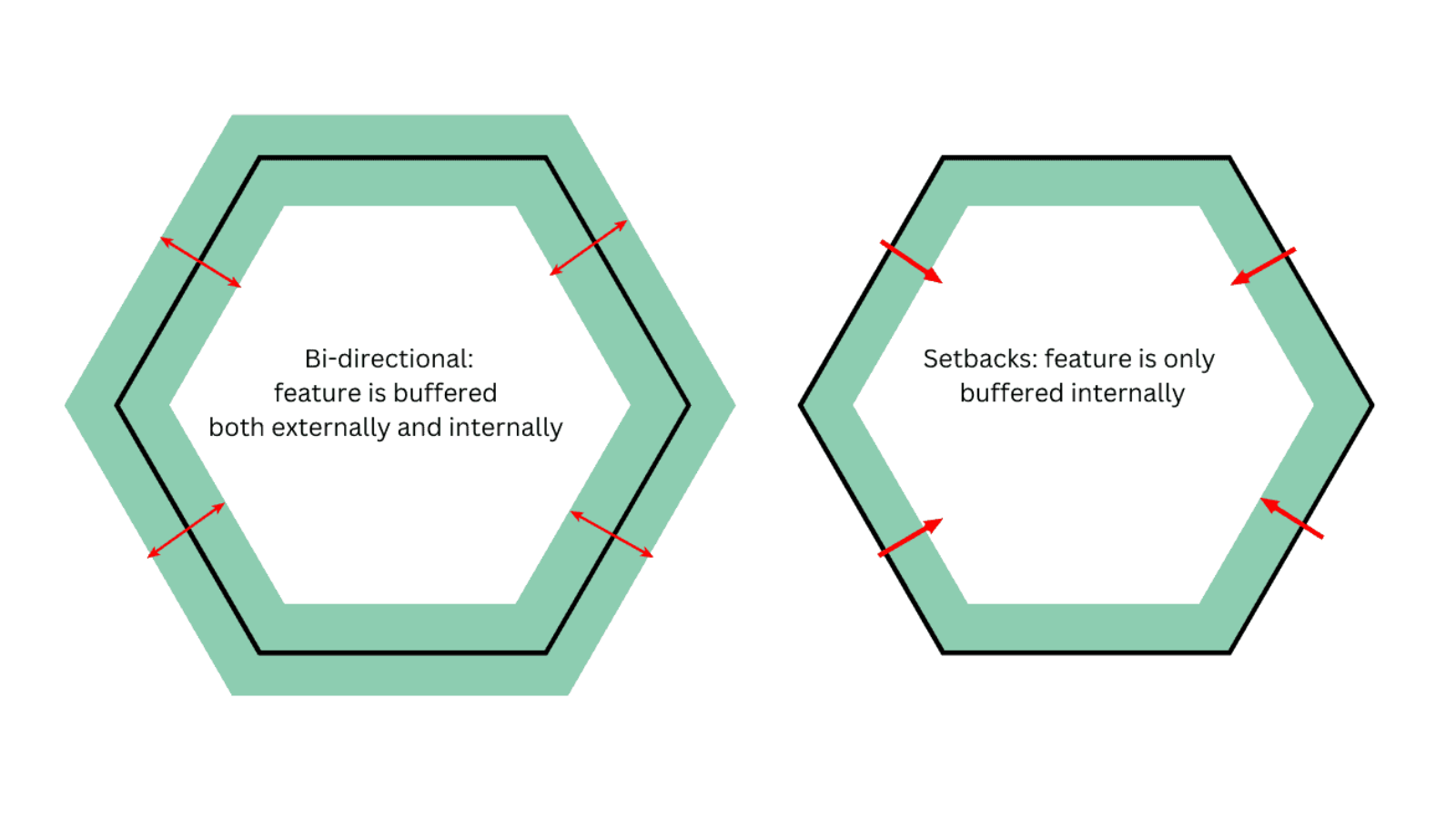
Buffer Direction for Polygons
Polygons, like city boundaries, can have bidirectional buffers extending both outward and inward, as well as setbacks that buffer only inward. Setback buffers, sometimes called negative buffers, shrink a feature’s area or perimeter.
Donut Buffers
Donut buffers, or ring buffers, involve creating two concentric buffers around a feature and excluding the smaller buffer area from the larger one. This creates a ring-shaped area around the feature.
Determining Buffer Size
The size of a buffer depends on the specific need and can be arbitrary, based on gut feelings, or causative, relying on prior knowledge. Buffers can also be measurable, using values like a viewshed, or mandated, following predefined rules like a 1000-foot ordinance around schools.
Understanding buffers in GIS is like exploring a versatile tool that aids in spatial analysis across various industries. Whether it’s safeguarding sensitive areas or studying demographics, buffers play a crucial role in making informed decisions.