Creating Features
When it comes to the world of Geographic Information Systems (GIS), you’ve got a vast playground of data at your fingertips. Imagine being able to slice, dice, and edit geographical information effortlessly, creating maps that capture the intricacies of our world. Well, you’re in luck, because today we’re going to dive into the top 25 must-know GIS editing tools. From basic maneuvers to advanced techniques, this cheatsheet will turn you into a GIS wizard. So, let’s get started!

The Straight Segment
Imagine constructing a straight line by merely pointing and clicking. The Straight Segment tool allows you to do just that. It’s as easy as connecting the dots.

Streaming Freehand
Next up is the Streaming Freehand tool. This nifty feature generates vertices as you move your mouse pointer, making it feel like you’re painting your data onto the screen.

Right-Angle Segment
Need perfectly square edges for your map? The Right-Angle Segment tool is your go-to. It ensures that all line segments have crisp, 90-degree corners.

Arc Segment
If you want to add some curvature to your line segments, the Arc Segment tool has your back. Whether it’s a circular or bezier arc, you can make your lines flow seamlessly.

Trace
Sometimes, it’s all about following along with an existing feature. The Trace tool creates new vertices by aligning your data with what’s already there.

Radial
Want to generate lines that radiate outwards from a central point? The Radial tool is your answer. It’s perfect for creating directional lines with ease.
Aligning Existing Features

Move
Moving features to a new location without messing with the vertices is a breeze with the Move tool. It’s like a magic teleportation device for your data.

Rotate
When you need to spin a feature in a circular motion around a central pivot point, the Rotate tool is your trusty sidekick.

Scale
Need to resize a feature? The Scale tool can help you do that. Whether you want to increase or reduce it, you can adjust the size proportionately.
Reshaping Existing Features

Edit Vertices
The Edit Vertices tool allows you to select, add, delete, and move vertices in an existing feature. It’s like giving your data a makeover.

Reshape
With the Reshape tool, you can update vertices in an existing feature using an input digitized line segment. It’s all about refining those details.

Replace
Sometimes, you need to swap geometry between features. That’s where the Replace tool comes in handy, making your job a whole lot easier.

Extend
If you need to elongate a line to connect with an existing feature, the Extend tool is your friend. It’s all about expanding your horizons.

Trim
Shortening a line to snap it to an existing feature boundary is a cinch with the Trim tool. No more messy overlaps!

Fillet
Adding a touch of curvature at the bend of two line segments is what the Fillet tool does best. It creates a smooth, circular path.

Generalize (Simplify)
For simplifying your lines or polygons, the Generalize tool is a lifesaver. It removes unnecessary vertices while keeping the basic shape intact.

Densify
Sometimes, adding more vertices to a line or polygon is essential. The Densify tool lets you do just that, at a specified distance, offset, or angle.

Smooth
When you want to soften corners and reduce jagged edges in your geometry, the Smooth tool comes to the rescue. It’s all about making your data look polished.
Dividing and Merging Existing Features

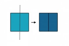
Split
The Split tool is your solution for cutting a polygon into separate features based on an existing line. It’s like a precise surgical procedure for your map.

Merge
When you need to combine two separate features into a single one, the Merge tool is here to help. It’s the ultimate unifier.

Buffer
The Buffer tool is all about widening your point, line, or polygon by a specified distance. It’s like giving your data some extra space.

Divide
If you need to cut a line or polygon into smaller segments, the Divide tool is the way to go. You can split it by distance, percent, or into equal parts.

Planarize
For those moments when your features intersect and need to be split, the Planarize tool is there to resolve the issue. It ensures smooth transitions.

Explode
When you have multipart features that need to be separated into individual single-part features, the Explode tool is your handy disassembler.
Coordinate Geometry (COGO)

Traverse
Now, let’s talk about Coordinate Geometry (COGO). The Traverse tool follows along a traveled path using direction, distance, and radius. It’s all about precision in your geospatial data.
The Power of GIS Editing Tools
In the world of GIS, editing tools are the artists’ brushes and chisels. They play a pivotal role in turning raw data into intricate, accurate maps. As we wrap up our exploration of these essential tools, it’s clear that their influence extends far beyond mere data manipulation.
With these tools, you become the master craftsman of geographical information, shaping, updating, and maintaining geospatial datasets. The result? Maps that not only reflect reality but also guide decisions in our ever-evolving world. So, embrace the power of GIS editing tools and turn your data into a masterpiece! And, if we missed any vital editing tools, be sure to drop us a comment below. Happy mapping!

