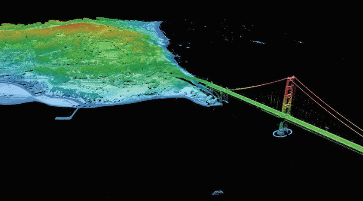
Have you ever grappled with the daunting task of finding LiDAR data sources, especially those that won’t cost you a dime? The search for free LiDAR data can be like navigating a labyrinth, but fear not! LiDAR, with its unique dataset intricacies and the enigmatic LAZ compression format, is a puzzle that we’re about to solve. It’s akin to having a shapefile with its own cryptic language!

The repositories housing LiDAR data are veritable treasures in the realm of Geographic Information Systems (GIS). They are where you find the magic – or shall we say, “the laser” (not the evil villain kind, though) that powers LiDAR technology.
In this special expedition into the world of LiDAR, we’re going to unveil 6 extraordinary sources of free LiDAR data, each brimming with its unique charm.
1. OpenTopography
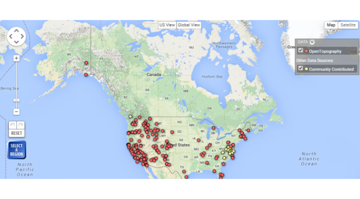
OpenTopography is like a beacon in the dark when it comes to free global raster and vector data. The beauty of OpenTopography lies in its open community system. Users register and can upload their own data, creating a vast repository accessible to all. It’s like a collective treasure chest of LiDAR data.
- OpenTopography is a collaborative LiDAR data repository.
- An intuitive web map displays LiDAR points as downloadable data, complete with metadata.
- Enjoy unrestricted access to topographic data.
2. USGS Earth Explorer
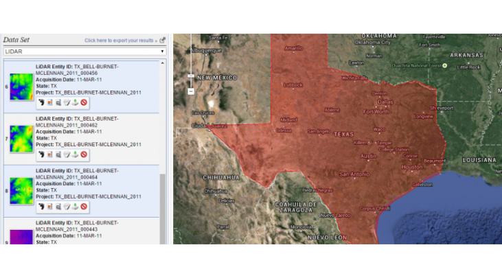
Formerly, accessing USGS LiDAR data involved navigating the intricacies of the CLICK (Center for LiDAR Information Coordination and Knowledge). Now, this service has transitioned to the USGS Earth Explorer.
Obtaining LiDAR data from the USGS Earth Explorer is a breeze:
- Start by defining your search criteria, be it KML, coordinates, or other specifics.
- Select the LiDAR checkbox in the data sets tab.
- Click the results tab to discover the available LiDAR datasets.
This user-friendly platform also sits atop our list of 15 free satellite data sources, making it a double win.
3. The United States Interagency Elevation Inventory
The United States is on a mission to create a National LiDAR Dataset, spearheaded by the United States Interagency Elevation Inventory (USIEI), with NOAA and USGS leading the way.
Many states have made strides in their own collections. The USIEI Inventory provides information about which states are involved, along with details on vertical accuracy, point spacing, and collection dates. Accessing the data may require a bit more sleuthing, but the National LiDAR Dataset Wikipedia page is your treasure map.
- LiDAR sources are scattered across the United States, with varying levels of data completeness.
- The USIEI LiDAR data viewer presents a nationwide list of high-accuracy topographic data.
4. NOAA Digital Coast
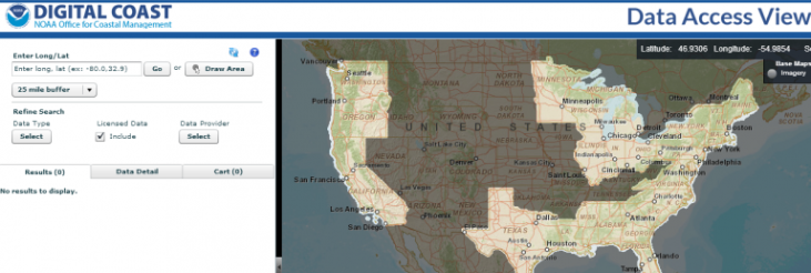
NOAA is on a mission to capture coastal LiDAR data and make it freely available to the public. Their Digital Coast web map makes finding coastal LiDAR data a cinch.
- A user-friendly web application for searching, analyzing, and downloading free LiDAR data.
- Simply draw your area of interest and click to download LiDAR data.
5. National Ecological Observatory Network (NEON)
NEON, backed by the National Science Foundation, is mapping out vegetation stands using airborne LiDAR technology. Visit the NEON Open Data Portal and search for LiDAR to discover a range of products with associated dates.
- While some data might not meet all user requirements due to quality control considerations, NEON’s airborne LiDAR data is brimming with potential.
- It includes airborne, aquatic, and terrestrial LiDAR instruments.
6. LiDAR Data Online
Could LiDAR data go global in the future, like optical imagery has? That’s precisely what LiDAR Online envisions. This data source is like a world map for LiDAR data, showing you exactly where LiDAR is available on Earth.
- LiDAR spans the globe, with a focus on Europe, North and South America, and Africa.
- The web map displays points representing free LiDAR data sources.
In summary, the world of free LiDAR data isn’t as mystifying as you might have thought. We’ve unveiled 6 remarkable sources where you can harness the power of LiDAR point cloud data without breaking the bank. Happy exploring!