For architects, engineers, and planners, great design begins with the right tools—and the right context. While cloud-based platforms like Autodesk Forma excel in the pre-design phase, they often lack critical environmental and spatial insights. That’s where Esri’s ArcGIS for Autodesk Forma transforms the game.
This intuitive app seamlessly integrates ArcGIS’s authoritative GIS data into the Forma environment. By combining real-world geographic intelligence with Forma’s powerful design capabilities, users can visualize projects in their true environmental and spatial context—unlocking deeper insights and elevating design quality from the very start.
The Value of ArcGIS for Autodesk Forma
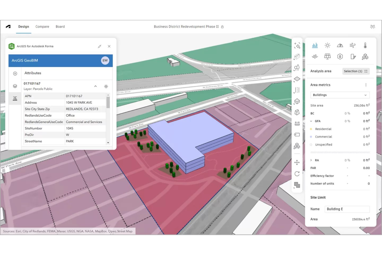
ArcGIS for Autodesk Forma offers a simple yet powerful way to bring spatial data, maps, and feature layers directly into your design workflow. By incorporating environmental, demographic, and infrastructure data early in the process, it ensures every decision is grounded in accurate, real-world information—enhancing quality, fidelity, and precision.
Embedding spatial context from day one means environmental considerations are addressed upfront, helping teams make smarter, data-driven choices. This proactive approach reduces the risk of costly revisions, prevents backtracking, and ensures designs evolve with the most up-to-date data available.
The integration between ArcGIS and Forma is streamlined and secure, preserving data integrity while simplifying workflows. The result? Better quality, higher accuracy, and greater project impact—with designs that stand out for their relevance, insight, and connection to the real world.
Benefits of ArcGIS for Autodesk Forma
1. Seamless Direct Integration
Connect ArcGIS data directly into Forma without losing accuracy or integrity. Work entirely within the Forma environment—no need to switch between platforms.
2. Always Current, Always Reliable
Access the most up-to-date spatial data with a single refresh. Eliminate the risks of outdated information and ensure every design decision is based on accurate, real-world data.
3. Cross-Platform Sharing
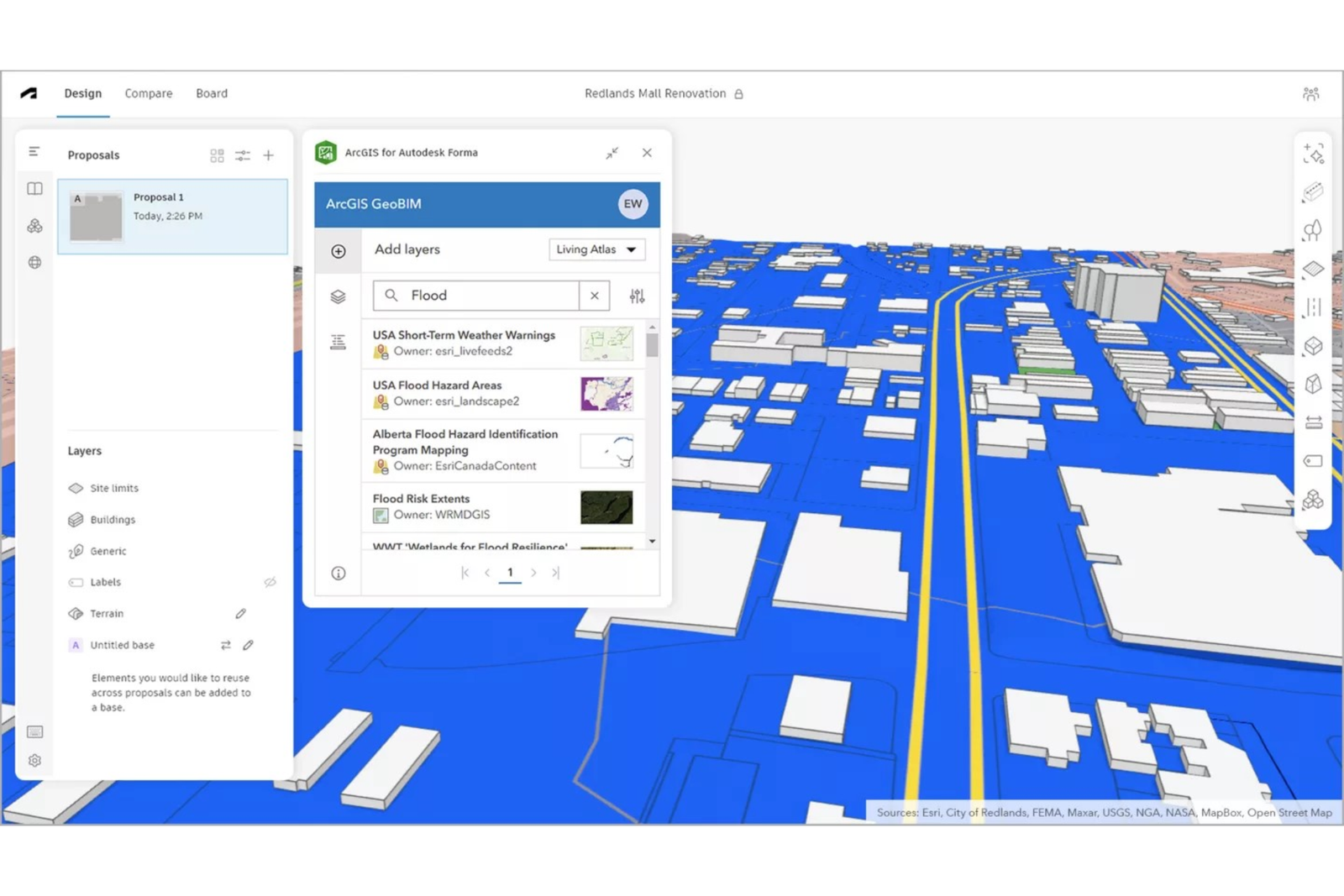
Leverage Esri’s basemaps, map layers, and Living Atlas content in Forma, then share spatially enriched designs across Autodesk tools—including Revit—for a smooth, connected workflow.
4. Early Problem Detection
Identify zoning, land use, parcel size, and environmental constraints from the start. Avoid costly revisions by addressing challenges before they impact the design process.
5. Unified, Streamlined Ecosystem
Work within a single, connected system that reduces processing time, safeguards data integrity, and eliminates fragmented workflows—saving both time and resources.
6. Rich, Contextual Site Awareness
Enhance designs with the latest drone and satellite imagery, infrastructure maps, zoning data, and more from ArcGIS Basemaps and the Living Atlas. Access additional insights from public and private sector contributions for a complete project view.a1212

How to Use ArcGIS for Autodesk Forma
Getting started with ArcGIS for Autodesk Forma is quick and straightforward. Just follow these four steps:
- Connect: Open your project in Autodesk Forma, go to Extensions, and select ArcGIS for Autodesk Forma from the list.
- Access: Sign in with your ArcGIS Online or ArcGIS Enterprise account. Make sure you have a Contributor user type or higher to unlock full functionality.
- Enrich: Browse and select the spatial data, maps, and geographic context you need. Integrate them directly into your Forma design to add real-world insight.
- Share: When ready, seamlessly transfer your enriched designs from Forma to Revit for further development and refinement
Esri + Autodesk – Powering Smarter, Context-Aware Design
Esri and Autodesk—two global leaders in their fields—are joining forces to place GIS (Geographic Information Systems) and BIM (Building Information Modeling) data at the heart of modern projects.
Their shared vision is an integrated, collaborative workflow that seamlessly connects data sources, enhances project understanding in real-world context, reduces inefficiencies, and supports the creation of sustainable, resilient infrastructure.
With authoritative geographic data from Esri’s ArcGIS embedded directly into Autodesk Forma, you can:
- Bring spatial context into the earliest stages of design.
- Better support architecture, engineering, and design communities.
- Incorporate rich geographic data—including buildings, zoning, roads, property boundaries, imagery, and more—into your projects.