If you’re unsure about trying out the open source GIS platform called QGIS, here are five really good reasons why you should give it a try.
QGIS doesn’t cost anything.
It’s what we call FOSS, which means Free and Open Source Software. Anyone with internet access can go to QGIS.org and download the software for their computer. It won’t cost you anything, and you can even look at the code it’s made from. The only thing you’ll need to spend is your time.
QGIS works on different types of computers.
QGIS works on all computers, like Macs, PCs, and Linux. It doesn’t matter which one you have. You can easily install QGIS on any of them. This makes QGIS available to more people compared to other paid options. For instance, ArcGIS Pro by Esri only works on Windows. QGIS is popular partly because there aren’t many good GIS programs for Macs. So, if you’re a Mac user who doesn’t want to deal with running PC-only software, QGIS is a great choice for you.
Comparing QGIS and ArcMap: Which GIS Software is Right for You?
More and more people are starting to use open source GIS.
More and more people are starting to use open source GIS software like QGIS. Even though it’s not as popular as Esri’s ArcGIS yet, QGIS is becoming a good choice for many instead of paid GIS software. The QGIS organization shares stories about how the software is being used by different government agencies and organizations, so people can see its real-life applications.
QGIS is gaining popularity in academia.
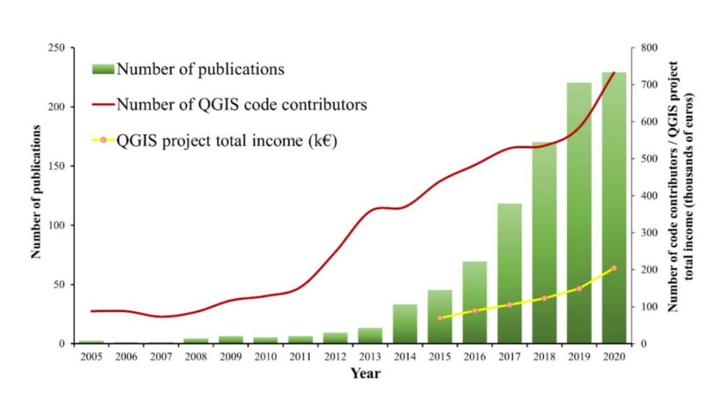
More and more people in schools and universities are choosing QGIS as their go-to tool. A study from 2022 looked at how many research papers mentioned using QGIS between 2005 and 2020. They found that 931 papers talked about using QGIS. When they looked at the numbers over the years, they noticed a big increase in the use of QGIS for research, especially in the last three years (2018-2020).
The Increase in People Using QGIS
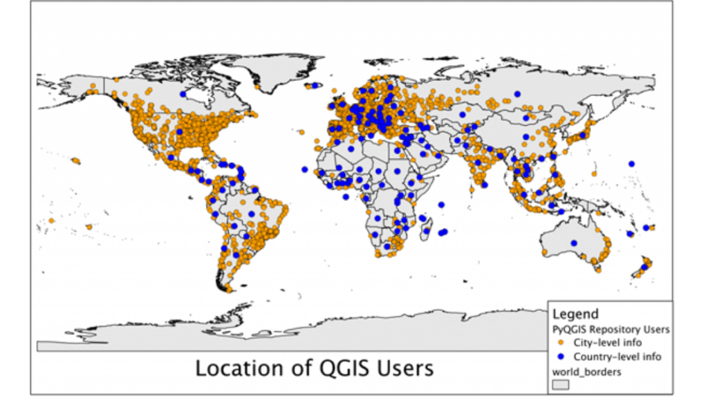
The number of people who use QGIS is tricky to figure out, but Gary Sherman, the person who started QGIS, did some investigating back in 2011. He looked at where in the world people were downloading QGIS from by checking their internet addresses. Based on his research, Sherman guessed in December 2011 that there were around 100,000 people all over the world using Quantum GIS.
More and more companies are choosing to use free GIS software instead of paying for expensive ones, which is seen as a growing trend in the GIS industry. Open source GIS software like QGIS is getting easier to use, and since companies want to save money, they’re switching to free software instead of buying expensive ones.
A survey done by Accenture in 2010 found:
- Two-thirds of the companies have a plan for using free software in their businesses, and another 32 percent are making one.
- Out of the companies using free software, 88 percent plan to spend more on it in 2010.
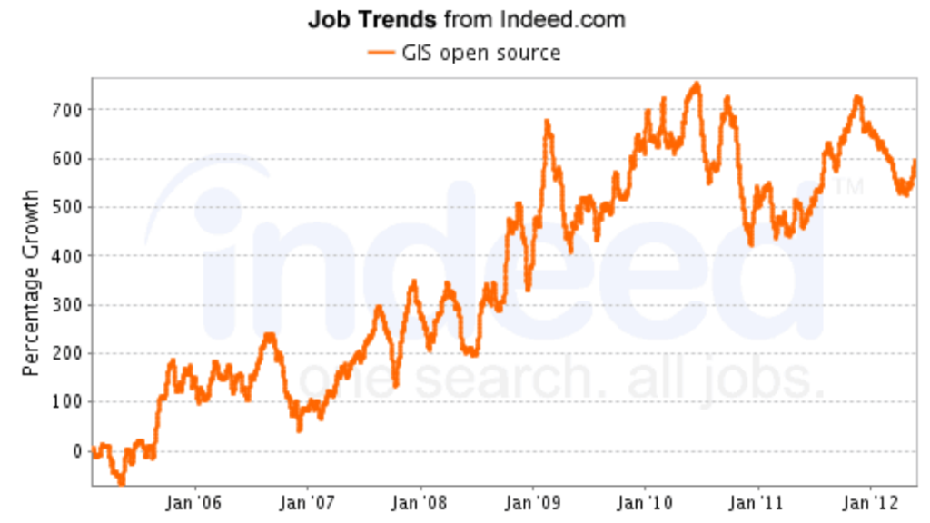
Landing a mapping software job just got easier! Many employers are now looking for experience with QGIS, a free program. This follows a growing trend of jobs asking for free software skills, and a recent survey showed 14% of mapping jobs already use some free software. To be a mapping whiz and impress employers, learning both free and paid programs is a great idea!
Lots of Help and Tutorials for QGIS
Don’t worry if you’re unsure about using QGIS; there’s a big community ready to help. Volunteers are always working to make QGIS better, fixing problems and adding new features. Nathan W. even made a cool video showing how QGIS has grown over time.
On the QGIS website, there’s a training manual with tutorials, or you can check out “A Gentle Introduction in GIS” for self-guided lessons. If you have questions, you can ask them on the GIS Stack Exchange website by tagging them with “QGIS.”
The QGIS website also has tutorials for beginners on things like working with different kinds of data and making maps. If you want more tips and tutorials, Anita Graser’s blog, “Free and Open Source GIS Ramblings,” is a great place to look. And if you’re just getting started with QGIS, there are more resources listed in the “Getting Started with QGIS” article.
QGIS Plays Nice with All Your Files
Whether you have maps in common formats like Shapefiles, KML, or even data from ArcGIS Online, QGIS can handle it all! It’s like a map-eating machine that can understand tons of languages. Plus, if QGIS doesn’t have a built-in skill for something specific, you can add “plugins” which are like special tools that give it new abilities. You can find and install these plugins right inside QGIS, making it super flexible for any mapping task!