Basemaps play a pivotal role in providing geographic context to maps and other data layers. These maps are essential for enhancing spatial analysis and modeling, whether you’re dealing with printed maps, digital displays, or web-based maps. They serve as a visual reference, ensuring that your audience comprehends the geographical information effortlessly.
For cartographers and map enthusiasts, a well-constructed basemap is a cornerstone of their craft. Let’s embark on a journey into the world of basemaps. What varieties of basemaps are at your disposal? And, more importantly, when should you deploy them?
Varieties of Basemaps
Maps are powerful communicators. To convey your message effectively, selecting the appropriate type of basemap is paramount. While a multitude of basemap types exists, only a handful are in common use today. Each type boasts its own set of advantages and limitations when it comes to visualizing and communicating information.
Here, we present examples of various basemap types, shedding light on their characteristics and ideal applications:
- Orthophoto BasemapOrthophoto basemaps offer a top-down perspective with intricate details of ground features. They are typically derived from satellite imagery but can also be crafted using aerial or drone photography. Their primary advantage lies in their ability to reveal Earth’s features and facilitate precise measurements, from building dimensions to street lengths.Examples: Google Satellite Imagery, Esri Imagery, and more.
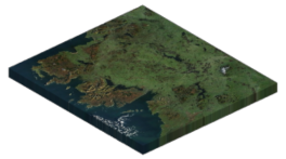
Orthophoto Basemap Orthophoto basemaps offer a top-down perspective with intricate details of ground features. They are typically derived from satellite imagery but can also be crafted using aerial or drone photography. Their primary advantage lies in their ability to reveal Earth’s features and facilitate precise measurements, from building dimensions to street lengths.Examples: Google Satellite Imagery, Esri Imagery, and more.

Topographic BasemapTopography forms the bedrock of any landscape, encompassing mountains, valleys, and surface rivers. A topographic basemap includes elevation data represented through contours. It can also incorporate natural and man-made features like administrative boundaries, hydrography, parks, urban areas, and transportation networks.Examples: USGS Topographic Basemaps, Swiss Topo, and more.

Satellite BasemapSatellite basemaps offer aerial views captured from space, making them indispensable for those seeking comprehensive aerial perspectives. Thanks to the repetitive orbits of satellites, these basemaps provide up-to-date imagery of various locations.Examples: Sentinel-2 Views, Landsat Imagery, and more.

Elevation BasemapThe digital elevation model (DEM) presents a digital rendition of Earth’s surface elevation. Elevation is the vertical distance from the ground surface to an ellipsoid model or geoid. It is a crucial asset for projects that involve elevation-related expenses.Examples: SRTM Digital Elevation Model, LiDAR DEM, and more.
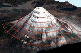
Contours BasemapElevation contours are another means of illustrating elevation variations in geographical areas. These lines depict constant elevation levels, with closely spaced lines indicating steep terrain and widely spaced lines signifying gentle slopes.
In Conclusion
Basemaps serve as the cornerstone of location-based applications and most mapping endeavors. They empower users to discover points of interest in their vicinity by offering geographic reference data. The applications of basemaps are numerous, catering to a wide array of purposes. If you have any inquiries about basemaps, please don’t hesitate to leave a comment below.